The Best Walking Trails in Britain That Are Accessible by Train
From the rugged ridges of the Peak District to peaceful lakeside trails in Berkshire, Britain's love of walking shows no signs of slowing down.
New research into the UK's most popular rail-accessible walking routes reveals where thousands of hikers are lacing their boots in 2026 – and where those keen to escape the crowds can still find spectacular scenery in peace.
The rankings come as new research from Regatta Great Outdoors suggests more people would spend time outdoors if getting there was easier. Almost six in 10 Brits (58%) say they would visit the countryside more often if public transport offered better connections, highlighting the growing demand for car-free adventures. The findings also reveal that more than one in five Brits (22%) don’t own or have regular access to a car.
When asked what's stopping them from getting outdoors more often, lack of time (32%) was the biggest barrier, followed by journeys taking too long (30%), travel costs (29%) and inconvenient public transport (26%).
With every walk in this guide located within easy reach of a train station, these routes make it easier to swap traffic jams for trails and enjoy some of Britain's best scenery without relying on a car.
Where Brits Are Flocking to & Where You Can Escape the Crowds
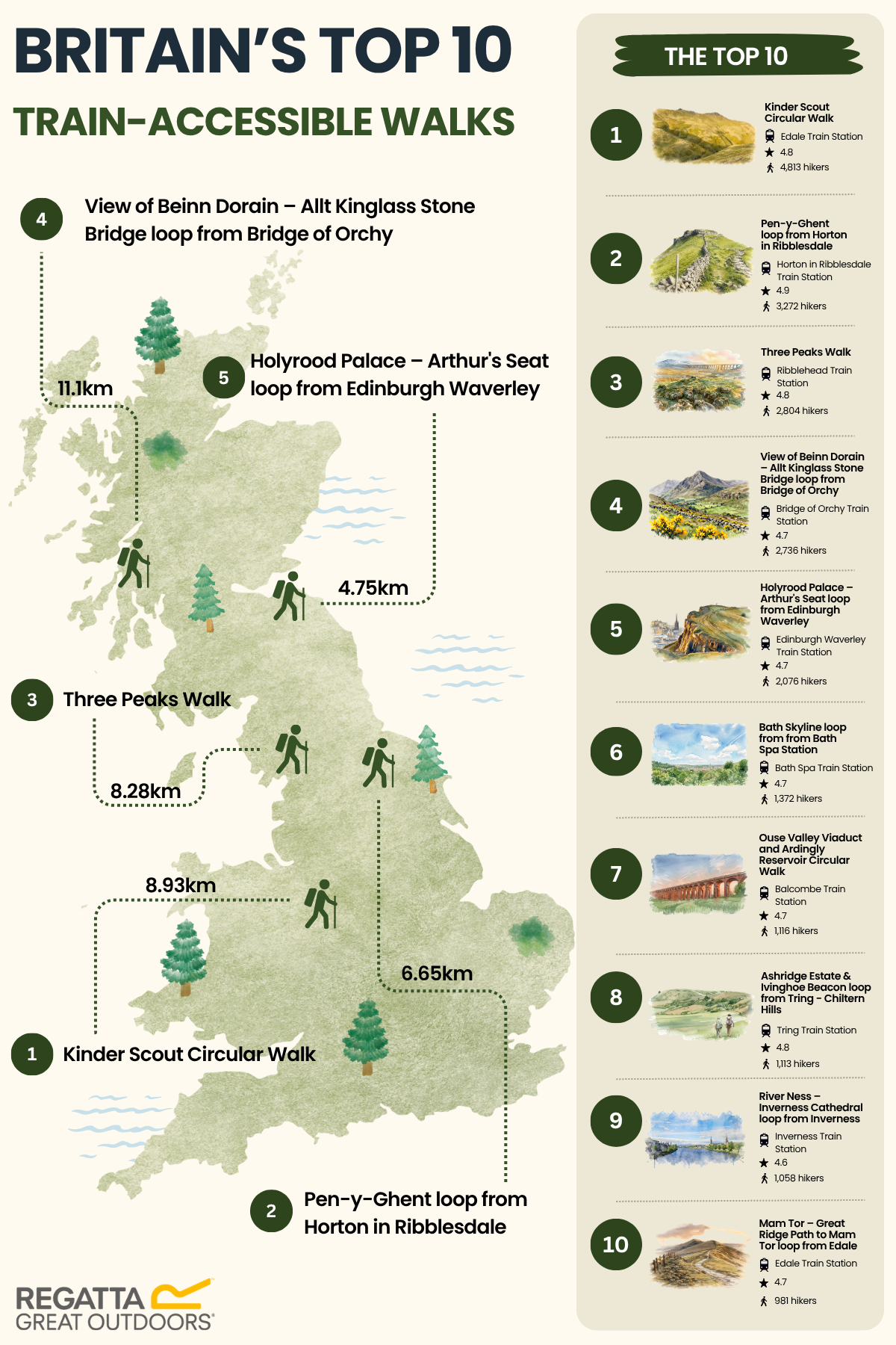
The UK's top five walks combine iconic landscapes, straightforward rail connections and routes that can be completed in a half day.
Leading the rankings is the Kinder Scout Circular Walk from Edale in Derbyshire, attracting 4,813 hikers and earning an impressive 4.8-star rating. The route takes walkers across the Peak District's highest plateau, offering sweeping views and rugged moorland landscapes.
In second place is the Pen-y-Ghent loop from Horton in Ribblesdale in North Yorkshire. Despite being shorter at 6.65 miles, the route boasts an impressive 4.9-star rating and has been completed by more than 3,200 hikers.
Rounding out the top three is the Three Peaks Walk from Ribblehead, another Yorkshire favourite that combines dramatic scenery with the iconic Ribblehead Viaduct.
Scotland claims fourth place with the View of Beinn Dorain – Allt Kinglass Stone Bridge loop from Bridge of Orchy. At 11.1 miles, it's the longest route in the top five, proving walkers are willing to put in extra miles for breathtaking Highland views.
Completing the top five is the Holyrood Palace – Arthur's Seat loop from Edinburgh Waverley, offering a unique combination of city sightseeing and panoramic views over Scotland's capital.
Hidden Gems – Where to Escape the Crowds
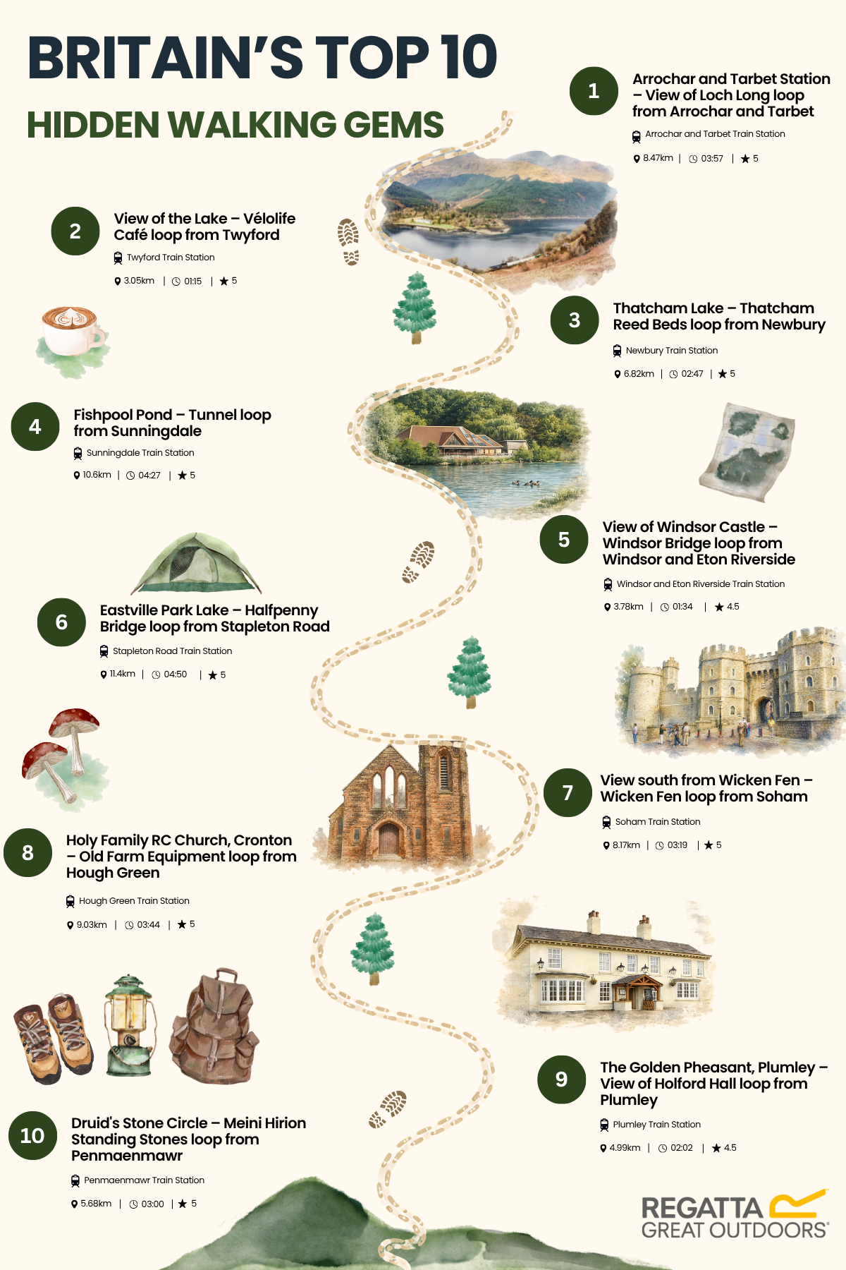
For those looking to trade busy trails for quieter paths, the hidden gems rankings shine a spotlight on lesser-known routes that deliver outstanding scenery without the footfall.
Remarkably, every hidden gem route has been completed by just 10 hikers, yet most have earned perfect five-star reviews.
Topping the list is the Arrochar and Tarbet Station – View of Loch Long loop in Argyll and Bute, which dramatic Highland landscapes meet a real sense of tranquillity.
Berkshire stands out as an unexpected hotspot, accounting for four of the top five hidden gems. Routes around Twyford, Newbury, Sunningdale and Windsor suggest you don't need to venture deep into the countryside to find peaceful walking trails within easy reach of London.
London’s Favourite Urban Walks
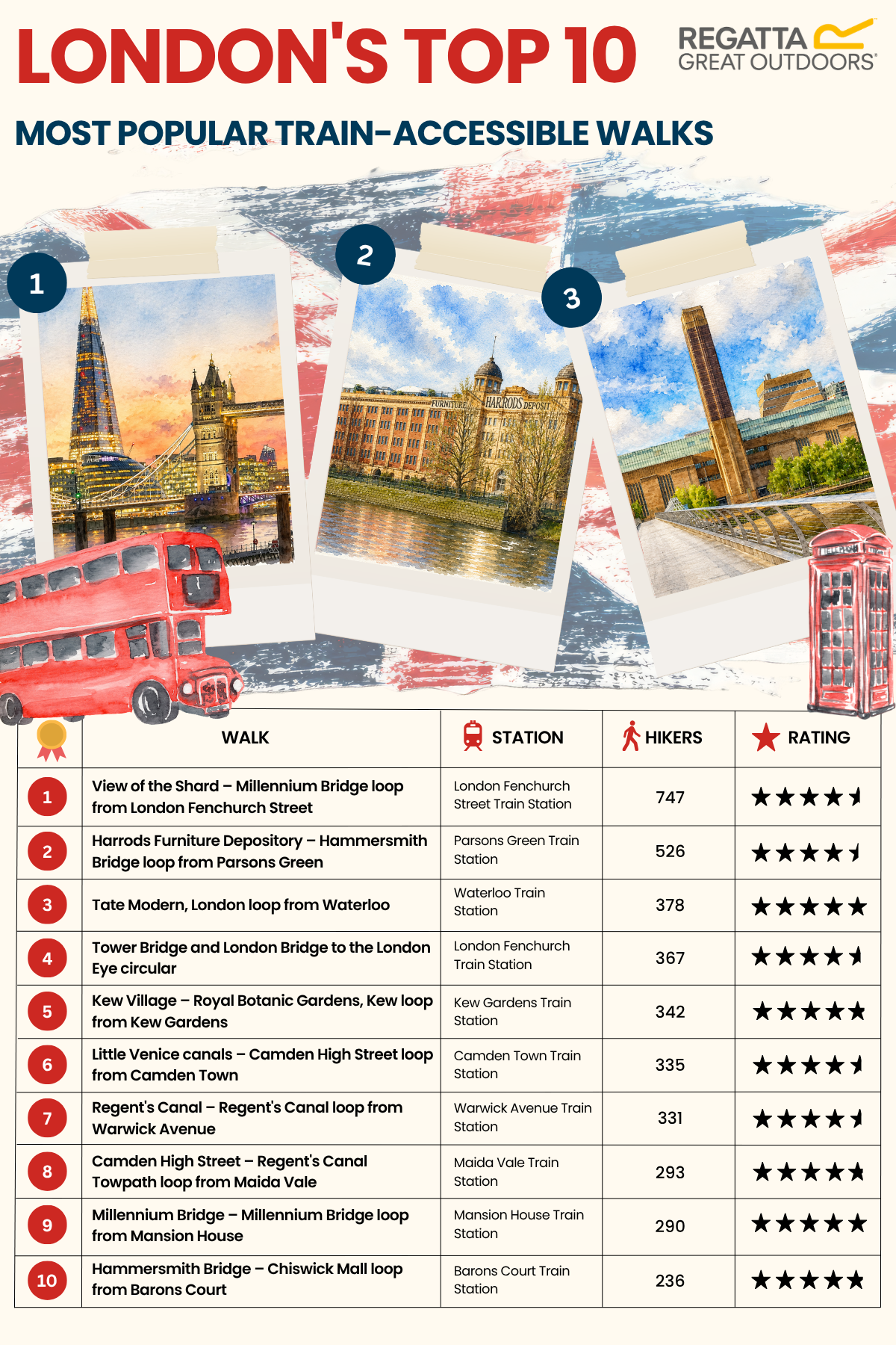
The capital's walkers are proving that great hikes aren't limited to national parks.
London's most popular routes focus on iconic landmarks and riverside scenery, with four of the top five following the Thames.
The View of the Shard – Millennium Bridge loop tops the rankings, while shorter routes such as the Tate Modern loop from Waterloo highlight growing demand for accessible urban walks that can fit around busy schedules.
For those seeking a greener escape, the Kew Village – Royal Botanic Gardens, Kew loop offers a quieter alternative to central London's busiest routes.
Methodology
We set out to reveal popular hiking routes that are accessible by a nearby train station. In order to do this, we:
- Used Komoot to create a list of hiking routes within the UK that were listed as being within walking distance of a nearby train station, an easy or moderate difficulty, and a estimated duration between 1 hour and 5 hours.
- This list of routes was then filtered by routes with at least 10 hikers that had used the route on Komoot, and an average rating of 4.5 or higher.
- For duplicate routes with different starting points, only the route with the highest average rating was included in the analysis. If two routes had the same rating, then the route with the highest number of hikers was used. This left 2,571 routes in total.
- A second list of routes was then created with the same criteria above that also had a nearby pub listed as a rest stop.
- For each route, Regatta then listed the name of the train station marked as the starting point via Komoot.
- Regatta then used Perplexity AI to list the city/town/village that the train station was located in, as well as the county. Missing data was then added in via manual research. To ensure data provided via Perplexity AI was correct, spot-checked train stations in the most popular counties were manually verified, along with the top 20 train stations for the highest number of routes.
- The number of routes was then analysed and categorised for each train station, city/town/village, and county, revealing which had the highest number of routes accessible by train station.
Data collected via Komoot is correct as of 5th June 2026.
A survey of 1,000 Brits aged 17+ were surveyed via OnePulse in July 2026.