About the Morecambe Bay Area
Morecambe Bay stretches from the south west coast of Cumbria to Fleetwood in Lancashire, taking in coastal towns such as Grange Over Sands, Morecambe and Heysham.
The area is well-known for its wildlife, particularly in spring and autumn, when it attracts a large variety of waders and seabirds. Hest Bank is a popular spot for watching the oyster catchers and other waders marching up the shore before the advancing tides. If you’re really lucky, you might spot seals lazing around the south tip of Walney.
There are a number of long distance walking and cycling routes that start in the Bay area, including the long distance cycle route Way of the Roses that runs from Morecambe Bay to Bridlington Bay, as well as the 137 mile walking route, the Lancashire Coastal Way, which follows the coastline from Merseyside to Cumbria.
This long-distance route traverses a variety of scenic landscapes and one of the loveliest is the distinctive limestone scenery of the Arnside / Silverdale area of outstanding natural beauty. It’s particularly well-known for the butterflies that call the hillside home. The five-mile circular route featured here allows to to cherry pick this highlight of the region and explore the coastline and hillsides over a gentle day’s walking.
About Arnside Knott
Arnside Knott is a small hill behind the Lancashire coastal village of Arnside. The area falls within the Arnside / Silverdale area that has been designated an area of outstanding natural beauty. The countryside here is owned and managed by the National Trust. It's well-known for its wildlife, especially the butterflies which flutter around the hillside in the warmer months.
The Arnside Knott Walk
This is a varied and enjoyable walk that can be enjoyed easily at a leisurely pace over the day, giving you plenty of opportunities to dally over the magnificent views, butterfly spot, enjoy the beach and explore the pleasant village of Arnside.
How to Get to the Arnside Knott Walk
The village of Arnside enjoys a pretty seaside location. The walk starts and ends here, giving you time to browse the shops and art galleries at either end of your walk or, perhaps, indulge in one of the tea rooms, treat yourself to fish and chips, or enjoy a cool drink or ice cream overlooking the bay.
Parking is available on the promenade in the village. Alternatively, you can reach the area by rail. Arnside railway station, on the Furness Line, offers connections to Barrow-in-Furness, Ulverston, Grange-over-Sands, Carnforth, Lancaster and beyond.
Walking the Arnside Knott Circular Walk
From the promenade, leave the village heading southwest along the seashore. Follow the sign marked footpath to New Barns Bay. The concrete path runs along the back of the beach and then behind the grassy sands until you reach the Bob In Café at New Barns.
In New Barns you have the option to take the beach path to Blackstone Point. If the tides are out, then this is a lovely option, but do heed the warnings. The tides around Morecambe Bay can be dangerous, so check timings before you set off, adhere to warnings and obey sirens if they sound.
If the tides are in or fast approaching, take the alternative route to the landward side of Frith Wood. You can rejoin the coastal path at Arnside Point.
If you are able to take the beach route from Blackstone Point, you’ll notice a natural ramp up the rocks on the far side of the bay. Take this to join the cliff top path, which leads you past Park Point and a caravan park. Here, you follow the public bridleway to Far Arnside.
Beyond Far Arnside, a footpath leftwards is signed to Arnside via the Knott. Follow it past another caravan site and into the National Trust area of Heathwaite where you’ll climb steadily up to the Knott.
How High is Arnside Knott?
The highest point of Arnside Knott is 159 metres (522 ft). The trig point lies just off the main path, close to a bench.
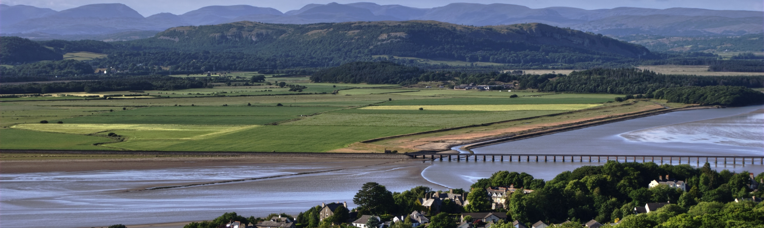
From here, you can enjoy beautiful vistas across the tidal sand and mud flats, towards the Lake District and over to the Bowland Fells and Yorkshire Dales. On a clear day, you can make out the distinctive shape of Ingleborough, one of the Three Peaks of the Yorkshire Dales Three Peaks Challenge in the distance.
Arnside Knott Butterflies
Arnside Knott is an area of outstanding natural beauty. Its limestone pavements and grasslands are renowned as a home for birds, butterflies, dragonflies and wildflowers. Thirty-four butterfly species have been recorded here, including the High Brown Fritillary, Duke of Burgundy and White-letter Hairstreak.
The area is a special meeting point for species at their most northern limit in the country and some at their most southern limit, such as the rare Scotch Argus butterfly.
The Return Leg from Arnside Knott
After enjoying the views from the top of Arnside Knott, head downhill back towards the village of Arnside. The route takes you left through a gate, across a field, and through woodland back to the road. The no-through road culminates in a footpath that drops you back onto the concrete footpath where you began your walk.
Back in the village, treat yourself to supper at one of the welcoming pubs, or perhaps an ice cream to enjoy on the promenade overlooking the bay.
What Do I Need to Walk the Arnside Knott Walk?
The route is gentle but do ensure you have good walking shoes or hiking boots. It's also always a good idea to pack a lightweight waterproof layer, such as these waterproof jackets.
Given the route is dependent on tides, we recommend you invest in the appropriate map (Ordnance Survey Explorer OL7 the English Lakes South Eastern area). This way, you can navigate an alternative route if needs be.
A waterproof map case is also a good idea, if not for the weather then for the beach!
The route over Arnside Knott can be steep in places. You might find it helpful to have a lightweight walking pole with you for some of the steeper sections.